Mapping with a garmin chip
-
John Bales
- JB2
- Posts: 2472
- Joined: Sat Feb 12, 2005 8:51 pm
Mapping with a garmin chip
Well, When I first use this mapping process for the first time, I did it on a real flat structure. Made about 15 passes trying to over lap so as to not miss anything. Let me back up a little. I have always said that I could map a structure faster and come to the fishing SPOTS a lot faster than this stupid depth finder would do. And then I ran into a situation that was hard to interpret and put it all together. So yesterday I made an attempt to make a few straight line passes and see what it shows. On the first flat structure I did this on, the overlap on my built in map was very similar to the original. It looked just like I thought it might with the exception of a couple of contour lines were a little closer together and it actually showed my anchoring spot, but like I said no big deal. It looked exactly like I thought it would. When night fishing the first time, we got into a really nice group of fish and before leaving it, we put a way point on it. At a later date and again at night, we were working in around ten foot and were working towards that way point. We were closer to the top of the bar but still in 12 ft of water but our way point was out into the lake about 50 more feet and that area was in 10 foot of water. Was this a little high spot, hump, bar? I was not sure. Did the deeper water where we were at 12 feet swing in a little closer to the shallows at that spot? I was not sure about the whole thing. So I do the straight line passes on this whole area from 6 feet out to the deepest water in the area which is about 16 feet. When I was done, I see a nice narrow ridge like bar with two inside turns that go up a ways towards the shallows and this is exactly where the hot spot was on that particular night. My interpretation would not let me see this area as it is. So.......... In this case, I have understood that there could be a time and place where this may be useful. John PS. By the way, I anchored off the end of that finger last night and got a 4 and a 3 1/2 bass and a 34 inch northern.
-
PhissingPhil
- 250 series
- Posts: 86
- Joined: Tue May 26, 2020 8:42 am
- Location: Graytown, Ohio
Re: Mapping with a garmin chip
John, Thanks for posting that information. I've been curious about how effective this auto-mapping software really is. The new sounders are a few generations beyond my Lowrance Gen2 HDS that doesn't have the mapping function. Have wondered about the effectiveness of these systems & whether they would provide enough detail for the money, The Navionics & other data sets, even when presented as accurate to within 1-foot are easily shown to be quite inaccurate in some areas. Having an auto-map function that actually works, even if not to extreme accuracy, would (I think) reduce the amount of time required to understand 'what's down there', especially since many of us aren't very fast at working it out using other methods. Time required is very important to us that have to travel some distance to be on the water we want to fish. Thank you for your impression that these things may actually be useful in the learning process. If I've misrepresented what you seemed to say, just smack me!
Phil
Phil
-
John Bales
- JB2
- Posts: 2472
- Joined: Sat Feb 12, 2005 8:51 pm
Re: Mapping with a garmin chip
Phil, I still say that if you use Don Dixons method of locating breaklines and follow each breakline around the feature, that is all you need and it is truly faster in my opinion. In my case, a heavy tall weedline and such a flat structure made it more time consuming. I turned towards the mapping stuff and it really opened my eyes. Jerry Borst is a great spoonplugger and he told me that the mapping tool is fantastic. I took his word for it because I really respect his knowledge. Navionics maps on Garmin is not very detailed. One of my buddies has Humminbird and his map of my lake put mine to shame. I would say that none of them are near spot on as far as shapes but none show the breaks. When you get some time in, you should be able to get the general shape of a structure in minutes if not too large. Take Care. John
-
Steve Craig
- JB2
- Posts: 1960
- Joined: Tue Feb 05, 2008 3:22 pm
- Location: Arizona
Re: Mapping with a garmin chip
John
I really love AutoChart Live. But as you noted, it doesnt show all the little details that a Spoonplugger needs to know.
I am thankful that i learned Dons way early on. I recall mapping most of the good structures on Cataract in a 6 hour time period, going back the next day, and whacking some great stringers of bass. Brian and I went on another day and caught some nice fish too.
The last time i was there, I ran the Auto Chart over several of the areas and was amazed at how much better my maps were over the Auto Chart. Then to my surprise, I was fortunate to see some maps that Buck and Terry had made while they were there many years ago,, and it makes a guy feel good to know that mine were VERY close to Bucks. I believe they were there in the mid to late 50's.
Anyway, I too, did find a use for Auto Chart, that will speed up the Mapping of certain structures that are sometimes confusing to figure out with standard practice. ( at least for me anyhow)
Religion is a guy in church, thinking about fishing.
Relationship is a guy out fishing, thinking about God!
Relationship is a guy out fishing, thinking about God!
-
John Bales
- JB2
- Posts: 2472
- Joined: Sat Feb 12, 2005 8:51 pm
Re: Mapping with a garmin chip
The funny thing is this. This area is on my lake that I have fished for 49 years and lived on for 33 of those years. Why don't I know this area by now? Because for years I used Mr. Perry's guidelines that kept me in the areas with the biggest and most bass. But now the place is chuck full of northerns and this area has become one of the few places where the bass can separate themselves from the dragons with the help of tall thick weeds. I never thought this area would be worth a hill of beans but the fact that the northerns pushed the bass into this area, and night fishing took me into this area and it was our best spot so far. Finding out that the fish can be anywhere they want to be so it is best if you are on a lake a lot not to pass up anything. At this point in my life, I am constantly being reminded that the learning never stops. John
-
John Bales
- JB2
- Posts: 2472
- Joined: Sat Feb 12, 2005 8:51 pm
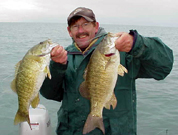
Re: Mapping with a garmin chip
- DSCF9616.jpg (107.13 KiB) Viewed 29379 times
Re: Mapping with a garmin chip
Very coolJohn. Thx for posting the pic
-
John Bales
- JB2
- Posts: 2472
- Joined: Sat Feb 12, 2005 8:51 pm
Re: Mapping with a garmin chip
There are reasons why we don't interpret some things, especially when there is a heavy weedline to deal with. Imagine this. We use the outside weedline to troll and draw a picture of the shape of what we are fishing. Trolling or following the base of the weedline will show us this. In my lake there are big areas of flats which run way out into the lake before you reach the drop off. There can be features a bit shallower that are covered with weeds that we cannot see by just following the outside weedline. I have found three such spots by using the mapping feature that I had no idea were there. The outside weedline only makes a slight turn or drops just a foot or so and you just do not think in your mind that just a little shallower is a nice looking finger that is a perfect little point. Yes you catch a fish once in a while there but when you add a tall thick weedline, it complicates things. You might say, why dont you look at the inside edge and maybe you will see it. That too is covered in weeds from about 5 feet all the way to the outside edge. In the spring, I am all over the inside edge yet still did not interpret that it was there. All three of these spots are perfect fingers and have become very good spot locked spots for the bass. One of my weaknesses is shallow water. Yes I get there a lot in the spring but when you are casting, you do not interpret as well as you do when the boat is moving at a good trolling speed. I ask myself what else am I missing? There is only one thing to do and that is to take a full day, start at the shoreline and overlap each pass and take the time to do the whole 160 acres. I am guessing that I will find areas in the shallows which are slight humps or depressions where the fish load up in the spring that I can take advantage of. There is a use for this mapping thing. I still fall back on the thought that you can still map a structure better and faster the old school way but believe it or not, some spots can be missed. John
Re: Mapping with a garmin chip
John - I think you make two very important points. First, the importance of mapping and interpretation, and why we can always improve in this area. The second, and it was almost what I was going to write about in the National, is that I believe most Spoonpluggers don’t pay enough attention to the shallows, both fishing or interpreting, especially in a situation where some type of cover (breaks) makes contour trolling difficult or impossible. Maybe I’ll tackle it in the next issue.
-
MuskyAddict
- 200 series
- Posts: 255
- Joined: Sun Jan 17, 2021 10:16 pm
- Location: Lake Minnetonka, MN
Re: Mapping with a garmin chip
I love this thread because I find it so inspiring. Not because of the electronic mapping tools but because of the knowledge learned over the years by spoonplugging veterans putting in the time to map and interpret their lakes. I have the hummingbird maps and auto-chart. I even bought the PC software package last year so I could fine-tune the maps after a day of fishing. But I purposely haven’t used it. I’m determined to learn my structure the old fashioned way and this thread has reaffirmed that is the right decision. Keep it coming boys. You are a great inspiration and motivation to us newbies.
I confess I AM using side scan imaging. I really struggle with a wheel boat and I find side scan is helpful following the weed edges and rock reefs - especially with a wide boat. It also shows me those weed patches or rock piles that I miss in my trolling.
I will buy a second tiller boat when finances allow.
Ken Smith, Minnesota
"If you asked me what I thought was the most important thing we have to master in becoming a great fisherman, I'd have to say it is in our ability to "interpret" the fishing situation"
-Buck Perry
"If you asked me what I thought was the most important thing we have to master in becoming a great fisherman, I'd have to say it is in our ability to "interpret" the fishing situation"
-Buck Perry
Re: Mapping with a garmin chip
Hey John, I run a saltwater transducer on the Garmin that allows me to map using Medium Chirp which is a different frequency than what my Vexilar flasher runs on. This way I get the best of both worlds, a simple map and real time depth from the flasher. Here is one of the maps of my favorite flatland reservoir up near the dam. These aids are very useful for me.
- Attachments
-
- Map.JPG (241.75 KiB) Viewed 29132 times
1990 Lund16 Pike Special,25hp Yamaha,Garmin 8610SXV,GT-15(15deg),GT36 UHD,LiveScope,Vexilar FL-12
Home of the Hop-R Jigs www.turboanglerfishing.com
YouTube:https://www.youtube.com/@turboanglerfishing
Rumble:https://rumble.com/c/TurboAngler
Home of the Hop-R Jigs www.turboanglerfishing.com
YouTube:https://www.youtube.com/@turboanglerfishing
Rumble:https://rumble.com/c/TurboAngler
-
John Bales
- JB2
- Posts: 2472
- Joined: Sat Feb 12, 2005 8:51 pm
Re: Mapping with a garmin chip
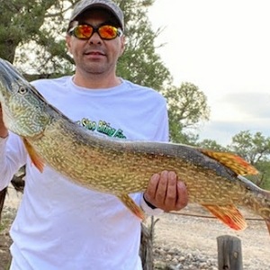
Looks nice, now show me the pics of the fish you got from doing this. John
Re: Mapping with a garmin chip
Jim
Great video (YouTube) from Navajo Lake. A true multi species fishing trip, smallmouth and largemouth bass, pike, catfish, and a salmon thrown in for good measure. All caught on the same Spoonplug!! Good text book trolling technique!
Thanks for sharing the video.
Good Fishing
TN Dave
Great video (YouTube) from Navajo Lake. A true multi species fishing trip, smallmouth and largemouth bass, pike, catfish, and a salmon thrown in for good measure. All caught on the same Spoonplug!! Good text book trolling technique!
Thanks for sharing the video.
Good Fishing
TN Dave
Re: Mapping with a garmin chip
Thanks Dave!
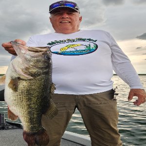
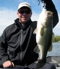
John, Here are some fish caught in the area that I mapped. This is my favorite Flatlander for a reason, no boat traffic, excellent water color and lots of fish, multi species! Without this map, I could have not found the hot spots. Navionics does not have a map for this lake so these areas not known to many.
John, Here are some fish caught in the area that I mapped. This is my favorite Flatlander for a reason, no boat traffic, excellent water color and lots of fish, multi species! Without this map, I could have not found the hot spots. Navionics does not have a map for this lake so these areas not known to many.
- Attachments
-
- LunkerBass.jpg (621.8 KiB) Viewed 29067 times
-
- Spoonplugger3.jpg (1.04 MiB) Viewed 29067 times
1990 Lund16 Pike Special,25hp Yamaha,Garmin 8610SXV,GT-15(15deg),GT36 UHD,LiveScope,Vexilar FL-12
Home of the Hop-R Jigs www.turboanglerfishing.com
YouTube:https://www.youtube.com/@turboanglerfishing
Rumble:https://rumble.com/c/TurboAngler
Home of the Hop-R Jigs www.turboanglerfishing.com
YouTube:https://www.youtube.com/@turboanglerfishing
Rumble:https://rumble.com/c/TurboAngler
-
Steve Craig
- JB2
- Posts: 1960
- Joined: Tue Feb 05, 2008 3:22 pm
- Location: Arizona
Re: Mapping with a garmin chip
Jim
You have some really good videos.
I have wanted to fish Navajo for a long time, but never seem to work out. Always something getting my attention elsewhere.
Your boat looks like my old Rebel I just sold back in Feb.
They are a well built boat for sure.
Can i ask about your camera setup?
We need to get together sometime, somewhere for sure.
Religion is a guy in church, thinking about fishing.
Relationship is a guy out fishing, thinking about God!
Relationship is a guy out fishing, thinking about God!