Page 1 of 3
CONTACT POINT
Posted: Fri Jul 09, 2021 7:50 am
by CHAMP
Where do you think the contact point would be on this structure for largemouth bass?
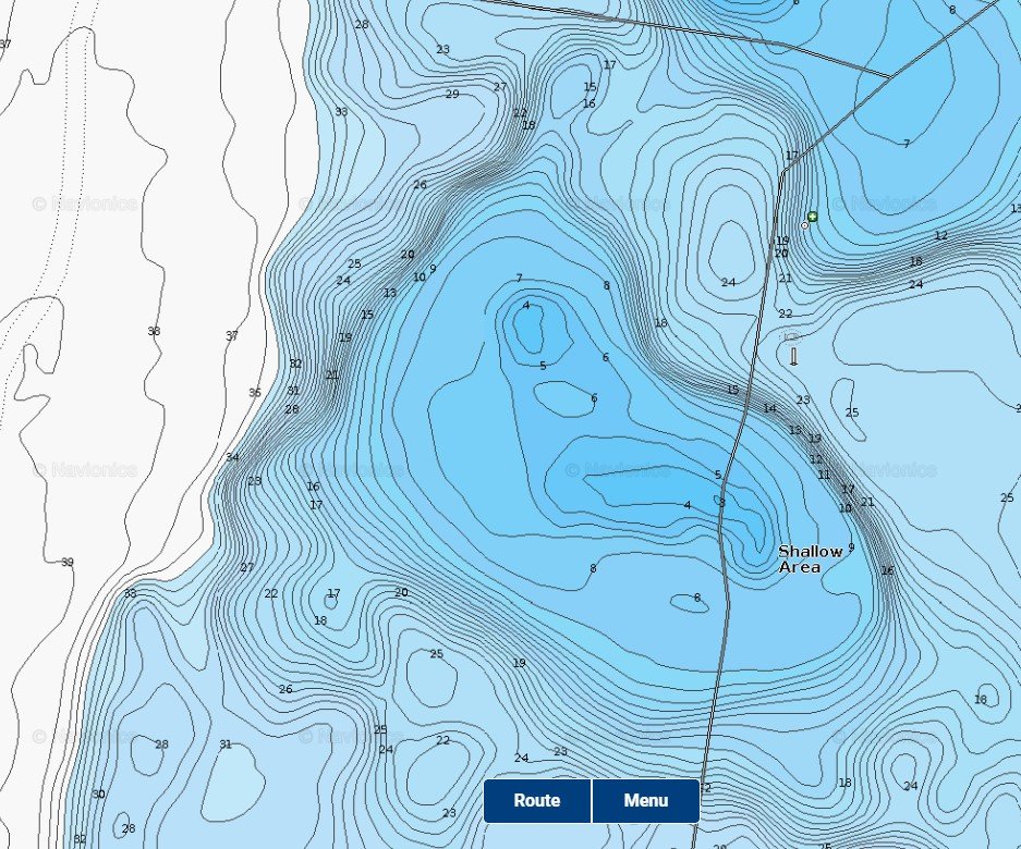
- Screenshot 2021-07-09 084657.jpg (206.7 KiB) Viewed 50484 times
On further migration which way would they go ?
Re: CONTACT POINT
Posted: Fri Jul 09, 2021 9:24 am
by Team9nine
All we can do is guess since we can’t see what kind of breaks are there and where they are located. Additionally, the accuracy of these maps is never spot on, and as readers, no idea of water clarity. That said, if I had to pick one area to focus my efforts at, I’d guess the area circled in red as the contact, and then the migration traveling along the yellow line (breakline). Given enough time or trips, I’d eventually fish around the entire structure though, as depths are such that under good weather and water conditions, several other areas could potentially be used by the fish.

- 14B6ADA9-1FD5-4D90-B9EB-F1976F3CB145.jpeg (323.37 KiB) Viewed 50474 times
Re: CONTACT POINT
Posted: Sat Jul 10, 2021 7:47 am
by TN_Explorer
I really like seeing these posts (I often go back to the old "Lake of the Month") threads. I find it very helpful to try and pick out the best spots and compare my results to other more experienced spoonpluggers. Thanks!
Re: CONTACT POINT
Posted: Sun Jul 11, 2021 4:31 pm
by Steve Craig
I like Brian's post and I agree.
I also would check out where that old roadbed goes up that point.
Good looking spot.
Re: CONTACT POINT
Posted: Thu Jul 15, 2021 5:08 am
by CHAMP
I would like to think the Brain and Steve for there interpretation , and I surely agree.
Re: CONTACT POINT
Posted: Mon Jul 19, 2021 9:24 pm
by MuskyAddict
Thanks for these posts. These are very helpful for this newbie. I see why the contact point was selected (sharper break to the deepest water). I’m curious of your thoughts on the deeper break just to the south (yellow highlights). It is not as sharp but deeper.
Ken
Re: CONTACT POINT
Posted: Mon Jul 19, 2021 9:58 pm
by joseph radunz
Not gonna speak for others but that is not directly related to shallow water, so maybe under bad conditions it’s worth a checking?
Joe
Re: CONTACT POINT
Posted: Mon Jul 19, 2021 10:20 pm
by joseph radunz
Since I’m posting- I might stop the migration route short of what others have said- they have access to shallow water long before the end of the point- I’m wrong lots….thoughts fellas?
Joe
Re: CONTACT POINT
Posted: Tue Jul 20, 2021 4:43 am
by CHAMP
Not gonna speak for others but that is not directly related to shallow water, so maybe under bad conditions it’s worth a checking?
Joe
I think you are 100% correct thats a dead end.
Since I’m posting- I might stop the migration route short of what others have said- they have access to shallow water long before the end of the point- I’m wrong lots….thoughts fellas?
Joe
Again I think u r 100 % correct they do have shallow water b4 the end of the bar , but Brain is showing them moving along the breakline toward shallow water. Without actually checking the area we don't really know which way they will go. This is just above water speculation.
This is y I posted this for everyone to chat about and hopefully some may learn from it.
Re: CONTACT POINT
Posted: Tue Jul 20, 2021 8:00 am
by Steve Craig
Ken,
We must remember that in order for a structure to produce, it must go "all the way". Deepest water in the "area", and all the way to the shallows.
Your spot only goes to the 28 foot hump and dead ends there.
You might pick up a walleye or two under bad weather, and this spot is Buck calls "Trolling water". The "Fishing water" is the area that Brian pointed out.
The very first place I would look however, is still the roadbed. Man made structure, as long as it goes from the deepest water "in the area" to the shallows. This roadbed does, and will hold fish.
Brians area will more than likely produce some of the biggest fish.
Re: CONTACT POINT
Posted: Tue Jul 20, 2021 9:32 am
by Team9nine
There are several reasons for why I drew the line along the entire break line.
First, Green book page 42-43 (Fig 21) references the fact that the route to the shallows may not be the shortest, most direct one. Fish will use the available breaks and breaklines, often ending up in what Buck termed “a crooked migration route.” No way to know for certain based on just this map…you’d have to check it out on the water.
Second, in bad weather or water conditions, the fish might not ever make it to the shallows, yet they could be active to some degree and just move along the break line, staying at a deeper depth. No telling how far some might go. It could resemble a Florida situation where they hit the deeper break line and scatter.
Third, while I’m guessing the contact point is where I circled, the end of my yellow migration route could also serve as a home area for another group of fish IMO. You have 30 ft of water on an inside turn, adjacent to a nice dog-legged point, a hump, a saddle, and the shallows, and all connected to the original contact point by the same break line. I could easily envision two groups of bass, one on each end of the yellow break line, each moving up in their respective home area, or each moving along the break line toward each other when active.
The only way to confirm or refute any of this would be to fish it…and I’d personally fish it all the first few times out until the fish tell me how they are using it. By “all,” I’d fish around the entire larger shallow area. There are a lot of 25 ft holes bordering this entire structure situation, and on my waters, that’s enough water depth to get used by the fish a majority of the time, as we tend to have much more stained water in our reservoirs compared to the natural lakes guys. We also develop thermoclines that will frequently eliminate use of the water deeper than 25 ft for some parts of the year. Under those conditions, areas like the one Steve mentioned could really shine.
Re: CONTACT POINT
Posted: Tue Jul 20, 2021 11:10 am
by CHAMP
I do believe any bass there would be in trouble if Brain ever fishes it.
Re: CONTACT POINT
Posted: Tue Jul 20, 2021 7:42 pm
by MuskyAddict
Wow. I didn’t even see the saddle until you mentioned it. Obviously I still have a lot to learn. Thanks for these. They are very helpful.
Okay, here is the next question. Let’s say this is a natural lake, clear water and weeds to 20’. Besides the obvious “go somewhere else”, would you approach this structure differently? How would you troll the breakline if the weeds from 20’ top out at less than 10’?
Ken
Re: CONTACT POINT
Posted: Wed Jul 21, 2021 10:57 am
by Team9nine
MuskyAddict wrote: ↑Tue Jul 20, 2021 7:42 pm
Okay, here is the next question. Let’s say this is a natural lake, clear water and weeds to 20’. Besides the obvious “go somewhere else”, would you approach this structure differently? How would you troll the breakline if the weeds from 20’ top out at less than 10’?
Ken
Was hoping a natural lakes guy would chime in on that question.
For me and my fishing approach if I was on such a lake, I’d start in the shallows on top of the hump/flat and fish the inside weed edge to start - if there was one - most likely by casting. This would especially be the case in the spring, or under really good weather and water conditions that promoted good movements. There is also the possibility other predators force the bass here (more on that later).
After that, I’d troll a 250 over the tops of that 8-10 ft tall weed growth, just ticking and ripping it through. Then, it’s on to the weed line on the deep edge. Troll the edges as best you can by stacking the lures along the weed line. This will give you time to see how the weed line is laid out, find any points or projections or inside turns. Mark the projections with a marker or a waypoint so that after the stacked trolling is done along the weed line, you can make good straightline passes on the base break line/weed line.
Trolling the deep weedline should be easiest on the west and northeast corners/sides of this structure because of how steep the drop appears to be. It would make for more of a “weed wall” which will be straighter, sharper and easier to troll in most all respects. Deeper than that, I’d look for things like the point you circled earlier, along with deeper breaklines, etc. that might exist but aren’t shown in this limited map.
I’d cast any areas I hit a fish in my trolling efforts, and also anchor just inside the weeds on points, bars or fingers and fan cast out using jump lures mostly to check slower speeds because of the depths involved.
One thing to keep in mind is the fish population. If you have a strong pike or musky population, they might dominate the outside weedline and deeper water, and force the bass into the weeds (or shallower), or to the secondary home areas such as the 25ft holes away from the deepest water. These smaller holes would likely need to be casted for the bass due to limited areas of open water. Things like weedless jigs, worms or dropshots would be natural choices here.
Another thing is the roadbed. You’d almost never see one on a natural lake, but you might in a deep clear situation like a highland lake that might also have weed growth similar to what you mention. Regardless, the road would be a clear path through the weeds and a natural highway for the fish leading directly to the shallows, and clear of weed growth because of the hard bottom. It would be easy to troll straight passes along the road, or make casts the same way using Spoonplugs if anchored shallow enough, or jump lures for slower presentations.
Re: CONTACT POINT
Posted: Thu Jul 22, 2021 7:51 pm
by MuskyAddict
Team9nine,
Thank you for that very thoughtful and thorough strategy. It’s amazing how much you “think” you understand from reading the green book & study guides until you get out on the water and get completely lost. These mapping and interpretation exercises are very helpful.
I don’t get a lot of inside weed edges unless there is a lot of sand and cabbage. These tend to be my best Muskie spots in the fall. Yes, I do have muskie (MN spelling

) and pike and they definitely dominate the deep weed edges. But I’m surprised at the number of large bass that can be found on those edges - especially when the larger predators are deeper due to what I now understand as weather and water conditions.
Ken
 ) and pike and they definitely dominate the deep weed edges. But I’m surprised at the number of large bass that can be found on those edges - especially when the larger predators are deeper due to what I now understand as weather and water conditions.