Due to a lot of different things that happened, we had to cancel the Bass Island trip. After some discussion Lake St Clair was chosen for a short 'Blitz' style trip and go for a weekend. So following my own procedures for planning a trip, I started looking at various computer based contour maps. This is what I found...
- Internet.Fran.1.jpg (189.74 KiB) Viewed 1136 times
Now we have to have confidence in our guidelines.
- Home of the fish is the deep water. Deepest in the Lake, Deepest in the area, or Deepest available.
- Structure will be our guide.
Before coming we had reports of fish being caught closer to the shore. We heard reports of some big catches made. So we knew fish were around. It wasn't at all like the Lake Erie trip where we stop to get a fishing license and the counter person said they hadn't seen any fish in a month. But the weather was a major challenge in my head. In Minnesota we had 68 degrees on Tuesday. Wednesday the forcast was for a Winter Storm Warning and up to 13" of snow. YUCK! When I woke up on Thursday, we had 1/2" in my yard. I had to work in the morning so on my way to the appointment I discovered my good feelings were premature. There was 5" of snow less than 2 miles from my house. By the time I was on the road to John's house in the afternoon I figured the snow would be all melted. However by the time I got to Eau Claire, Wisconsin there was 15" of snow with very little visibility. Very blizzard like. I kept going. 150 more miles and I was in the Madison area. What I found was moderate thunderstorms, lightening, wind, and hail. And this front was charging like a bull straight east and I had very low expectations for fishing.
So really tough weather condition approaching and a shallow, clear body of water. Well I was looking forward to some nice company with fellow Spoonpluggers. Always a good time whether you catch fish or not. Now what happened weather wise is a very unusual event and I will try to write about that in another thread but lets just say the front got about halfway between Madison and Chicago - and then turned around went back west! At Lake St. Clair we never had a frontal passage so we had what was approximately a day 5,6,and 7 post frontal condition. Very Lucky indeed.
John and I left the ramp and proceeded where we thought there was a bar we could work. While we had good weather, there was still wind and it churned up the water into a chocolate milk color. Normally this would be pretty good for fishing but if the water is normally clear and you have a suddenly dark or muddy water condition - it can be pretty tough fishing. Seeing the first bar in the darkest water we decided to go to the next bar we found on the map. While the water wasn't clear it was starting to get a green tint the farther we went out so we trolled out to the next bar - approximately 3 miles from shore and 3 miles south from the ramp.
On the way there I hooked a fish. We threw a marker and proceeded to troll and cast the area. We caught no more fish. What we found was that the fish was just in the middle of the flat. We couldn't determine what lead him to the spot and after 30 minutes we continued the next bar. This is what it looks like on the map...
- Internet.Fran.2.jpg (70.02 KiB) Viewed 1136 times
Here is what we saw in the area around the bar that didn't produce fish...
- Internet.Fran.3.jpg (52.09 KiB) Viewed 1136 times
- Internet.Fran.4.jpg (77.77 KiB) Viewed 1136 times
Mr. Perry wrote that Small and Large mouth bass are the same. However there are some differences. For the purposes of this post - the most important thing is that Smallmouth prefer to take a free swimming lure over a bumping lure. For the past 5 years I have experienced enough Smallmouth fishing to believe this fact. So our normal procedure is to let out enough line so the lure bumps then reel in until the lure runs free. We try to crack the code by changing the distance above the bottom to find where the fish are. What I like to do is start by using the smallest lure that will get to the depth with the longest line. So I found that using a #7 deep diving crankbait with about 200 feet of line out gave me the perfect depth. While we did find the fish in this configuration - we found that the fish would have eaten just about anything put in front of them, except Bales Blades. Really strange.
Our first fish was taken approximately 200 feet north of the bar. We threw a marker, tried cast for a while then continued trolling. Second fish was taken about 300 feet south of the bar. So now we have markers far apart. We couldn't really find one spot where the fish were, so we started doing straight line passes parallel to the markers. This is where we found the answer.
As the free running lure came across the edge of the bar it would actually start touching the bottom. There was no change of depth on the sounder. The bottom got more jagged and hard. As soon as we caught the next fish we and threw another marker. At that point we anchored and casted to the fish. I think we got about 10 fish. After the fish slowed down we started drifting through the two closest markers while vertical jigging tubes.
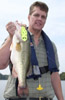
This location gave us the biggest fish of the trip and while John and I had personal best day catches on two consecutive days, I feel the most important learning I had was going to this location on the map. Catching a fish, and working the situation until we had the answer. I believe 9 out of 10 guys (including me) would have certainly looked at the area but seeing the area was mostly flat, would have just left the area. But we caught an adult fish and we worked the it till we had the answer. While the shape is a bar but I am not certain that description is the most correct. I am thinking reef is more accurate but it was very subtle.
I love my electronics. But in this case we never saw any real significant change in depth nor did we see any fish on the sounder. Only the lures told us the answer. I would like to say that without the GPS map we would have had a hell of a time finding the area. Without markers we couldn't have pinpointed the fish. Line sights would have been very tough to find.
Now with the size of the structure and the distance from shore and the waves (damn near fell out of the boat while on the front deck) - we were still able to spend less than an hour to narrow the spots covering miles to less than 200 feet. Know the procedures, follow them, and have the faith that you're doing it correctly. Lots of good lessons.
Thanks